


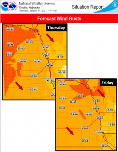
An intense upper disturbance moving through the region will induce very strong northwesterly winds through tonight. Locations west of a line roughly from Wynot to Pawnee City can expect northwest winds from 25 to 35 mph with gusts up to 60 mph.
Meanwhile east of that line northwest winds from 20 to 30 mph with gusts up to 45 mph can be expected. In addition to this blizzard or near blizzard conditions are expected to develop late tonight. The hazardous conditions will likely impact travel east of a line from about Hartington to Humboldt. .
Through Friday morning the region will continue to experience very strong northwesterly winds. Locations west of a line roughly from Wynot to Pawnee City can expect northwest winds from 25 to 35 mph with gusts up to 60 mph. Meanwhile east of that line northwest winds from 20 to 30 mph with gusts up to 45 mph can be expected.
Blizzard or near blizzard conditions will still be possible Friday morning. The hazardous conditions will likely impact the morning commute over area east of a line from about Hartington to Humboldt.
Total snow accumulations are expected to range from 3 to 5 inches over southwest Iowa with 1 to 3 inches then east of a line roughly from Knox county to Pawnee in eastern Nebraska. Otherwise an inch or less looks possible elsewhere across eastern Nebraska.


