…FLASH FLOOD WATCH IN EFFECT FROM 7 PM CDT THIS EVENING THROUGH MONDAY MORNING…
This Hazardous Weather Outlook is for portions of southwest Iowa…west central Iowa…east central Nebraska…northeast Nebraska and southeast Nebraska. .
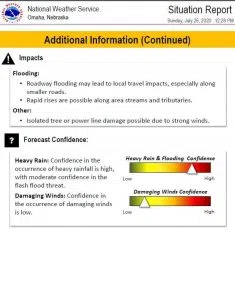
This Afternoon and Tonight: While scattered showers and isolated thunderstorms continue to bubble up in southeast Nebraska and southwest Iowa this afternoon, more widespread thunderstorms are expected to develop after 4 PM near a line from Harlan to Blair and David City.
This line will expand southward during the late afternoon and evening. Intense thunderstorms with heavy rain and damaging winds could occur through the evening. Then continued development of storms near and south of Interstate 80 is possible overnight.
Total rainfall could total 2 to 4 inches in some spots before the rain diminishes late tonight. Heat index values 100 to 105 are likely for a few hours this afternoon in far southeast Nebraska and far southwest Iowa.
Monday through Saturday. A chance of thunderstorms returns to the forecast by Wednesday.
…FLASH FLOOD WATCH IN EFFECT FROM 7 PM CDT THIS EVENING THROUGH MONDAY MORNING…
The National Weather Service expanded the Flash Flood Watch to include portions of southwest Iowa and Nebraska, including the following areas, in southwest Iowa, Fremont, Mills, Montgomery, Page, and Pottawattamie. In Nebraska, Cass, Douglas, Lancaster, Otoe, Sarpy, and Seward.
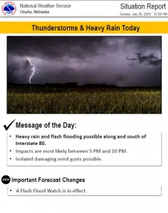
Heavy rain is expected to develop this afternoon with an increase in intensity this evening. Heavy rain will continue through much of the evening before the axis of heaviest rain settles a bit south. Many areas could see anywhere from 2 to 3 inches of rainfall, with some higher amounts possible. Heavy rainfall could lead to some areas of flash flooding.
PRECAUTIONARY/PREPAREDNESS ACTIONS… A Flash Flood Watch means that conditions may develop that lead to flash flooding. Flash flooding is a very dangerous situation. You should monitor later forecasts and be prepared to take action should Flash Flood Warnings be issued.